How To Allow Deicmal Points In Field Arcgis
ArcGIS is a powerful geographic information system (GIS) used by professionals worldwide to capture, analyze, and visualize spatial data. One frequently encountered challenge is configuring fields to accept decimal points, which is crucial for maintaining data accuracy in mapping, surveying, environmental analysis, and numerous other applications.
Whether you are tracking elevation, population density, or pollution levels, ensuring your fields record decimal values correctly can make the difference between precise analytics and misleading results.
Getting decimal points to work seamlessly in ArcGIS requires a deep understanding of data types, field configuration, and software limitations. Many users face issues with field rounding, truncation, or unintended conversion to integer values, especially when importing datasets or integrating with external sources.
This article will guide you through every aspect of allowing decimal points in fields within ArcGIS, from foundational concepts to advanced troubleshooting, ensuring your spatial data retains its granularity and reliability.
Key Takeaways
- Decimal points in ArcGIS fields depend on correct field type selection and configuration.
- Avoid using integer data types if you need decimal values; opt for float or double.
- Data entry, import, and export processes can affect decimal precision, understand their impact.
- ArcGIS Pro and ArcMap offer different methods and interfaces for field management.
- Troubleshooting rounding or truncation issues often involves understanding software limitations and workflows.
- Real-world examples illustrate best practices for maintaining decimal accuracy across GIS projects.

Credit: pro.arcgis.com
Understanding Field Types In Arcgis
Choosing the right field type is the foundation for allowing decimal points in ArcGIS. The software distinguishes between several field types, each with its own rules for data storage and precision.
Numeric Field Types
ArcGIS supports multiple numeric field types, but only certain ones allow decimal points:
- Integer: Stores whole numbers only, no decimal points.
- Float: Stores numbers with up to 7 significant digits; allows decimal points.
- Double: Stores numbers with up to 15 significant digits; allows decimal points.
Choosing between float and double depends on your precision requirements. For most GIS applications, double is recommended when high accuracy is needed.
| Field Type | Allows Decimals? | Precision | Typical Use |
|---|---|---|---|
| Integer | No | None | Counts, IDs |
| Float | Yes | ~7 digits | Moderate precision |
| Double | Yes | ~15 digits | High precision |
Text Field Types And Decimals
Text fields can technically store decimal values as strings, but this is not recommended for numerical analysis. Calculations and sorting will not behave as expected, and the risk of data entry errors increases.
Domain And Subtype Considerations
Domains and subtypes allow for controlled data entry, but if you need decimal values, ensure your domain values are compatible with float or double fields.
Credit: doc.esri.com
Configuring Fields For Decimal Points In Arcgis Pro
ArcGIS Pro is the latest desktop GIS application from Esri, featuring a modern interface and enhanced data management capabilities. Setting up fields to accept decimal points in ArcGIS Pro involves several steps.
Creating A New Field With Decimals
- Open the Attribute Table: Right-click your layer and choose “Attribute Table”.
- Add Field: Click the “Add Field” button.
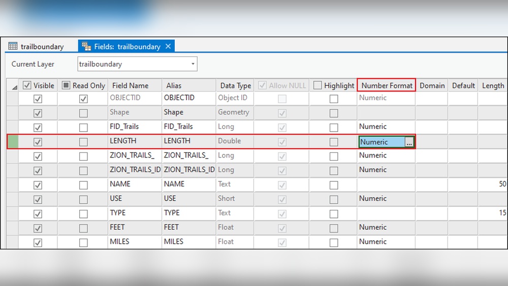
- Choose Data Type: Select “Float” or “Double” from the data type dropdown.
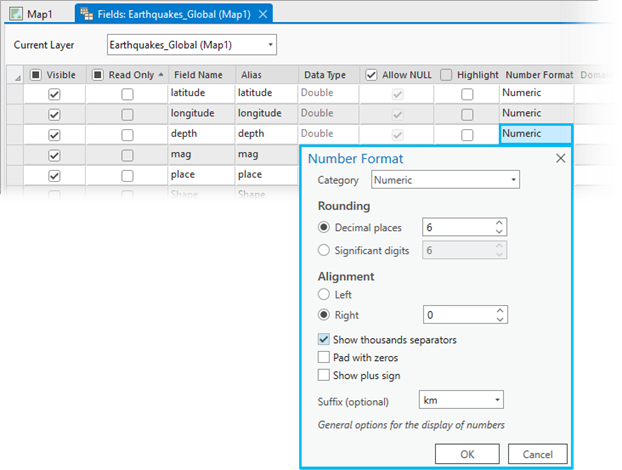
- Set Precision and Scale: Precision controls the total number of digits, while scale sets the number of digits after the decimal.
- Save and Close: Complete field creation and start entering decimal values.
Editing Field Properties
If you already have a field, you may need to adjust its properties to allow decimal points:
- Fields cannot be converted from integer to float/double directly. You must create a new field with the correct type and transfer data.
Example:
- If you accidentally created an “Integer” field but need decimals, add a “Double” field, use the Field Calculator to copy values (with decimals), and delete the original field.
Importing Data With Decimals
When importing CSV or Excel files:
- Ensure your numeric columns are formatted as numbers (not text) with decimals.
- ArcGIS Pro will attempt to auto-detect field types, but manual review is recommended.
- Use the “Fields View” to adjust data types before finalizing import.
Pro Tip:
Always define field types before entering data. Changing field type after data entry is not possible without creating a new field.
Allowing Decimal Points In Arcmap
ArcMap remains widely used in many organizations. Its workflow for field creation and editing differs from ArcGIS Pro but still follows the same principles.
Adding Fields In Arcmap
- Open the Attribute Table: Right-click the layer, select “Open Attribute Table”.
- Start Editing: Click “Editor” > “Start Editing”.
- Add Field: Click “Table Options” > “Add Field”.
- Select Field Type: Choose “Float” or “Double”.
- Set Precision and Scale: Input desired values for precision (total digits) and scale (decimal digits).
Editing Existing Fields
ArcMap does not allow changing a field’s type once created. To fix an integer field:
- Add a new float/double field.
- Use the Field Calculator to transfer values, applying any necessary decimal formatting.
Importing Data With Decimals
- Use ArcMap’s “Add Data” wizard to import CSV or Excel files.
- Review field types, ArcMap may default to integer if decimals are not present in the first rows.
- Manually change field types where necessary and re-import data.
Example:
A survey dataset imported as integers loses all decimal precision. Creating a new double field and recalculating values restores the intended accuracy.

Credit: support.esri.com
Managing Decimal Precision And Scale
Precision and scale settings are vital for controlling how many decimal places your data can store and display.
Understanding Precision And Scale
- Precision: Total number of digits stored, both sides of the decimal.
- Scale: Number of digits to the right of the decimal point.
For example, a field with precision 8 and scale 3 can store values up to 99999. 999.
Setting Precision And Scale
During field creation:
- Enter precision and scale values that match your data requirements.
- Avoid excessive precision, higher values require more storage and can slow performance.
| Precision | Scale | Maximum Value | Example Stored Value |
|---|---|---|---|
| 5 | 2 | 999.99 | 123.45 |
| 8 | 3 | 99999.999 | 87654.321 |
| 10 | 5 | 999999.99999 | 543210.12345 |
Editing Precision And Scale After Creation
ArcGIS does not allow changing precision and scale for existing fields. The workaround is to create a new field and migrate data.
Warning:
If you import data with more decimal places than your field’s scale allows, ArcGIS will round or truncate values, leading to loss of accuracy.
Common Issues And Troubleshooting Decimal Points
Even when fields are configured correctly, users may encounter issues with decimal data. Understanding and fixing these problems is essential for maintaining data integrity.
Decimal Rounding And Truncation
- If the field scale is too low, decimal values will be rounded off.
- Example: Entering 123.456 into a field with scale 2 will store 123.46.
Data Import Problems
- CSVs or Excel files may be interpreted incorrectly if decimal formatting is inconsistent.
- Ensure all decimal values use a period (.) And not a comma (,), especially for international datasets.
Field Calculator Errors
- Using the Field Calculator with integer fields does not preserve decimal points.
- Always use float/double fields for calculations involving decimals.
Real-world Example
A city planning office imported traffic count data and noticed all speeds were rounded to whole numbers. Investigation revealed the source Excel file had decimal values, but ArcGIS interpreted the field as integer due to the first row lacking decimals.
The solution involved creating a new double field, re-importing, and recalculating values.
Advanced Techniques For Decimal Management
For enterprise environments and large datasets, managing decimal points involves more sophisticated workflows.
Using Geodatabases
- Geodatabases support advanced field configuration, including decimal precision.
- Use the “Fields” tab in ArcGIS Pro to adjust settings before importing large datasets.
Integrating With External Data Sources
- When linking ArcGIS to external databases, ensure field types match. For example, SQL Server’s “float” maps to ArcGIS “double”.
- Use OLE DB connections for robust data integration.
Automating Decimal Handling With Python
ArcGIS supports Python scripting for field management:
- Use the “arcpy” library to add fields, set types, and migrate data programmatically.
- Automate precision/scale adjustments for batch processing.
Example Python snippet:
import arcpy
arcpy.AddField_management("my_layer", "elevation", "DOUBLE", precision=8, scale=3)
Pro Tip:
Automate field creation and migration for large projects using Python to ensure consistent decimal handling.
Real-world Examples And Case Studies
Examining how organizations solve decimal point challenges in ArcGIS provides practical insights.
Case Study 1: Environmental Monitoring
An environmental agency tracks pollutant concentrations in river systems. Initial data entry used integer fields, leading to loss of decimal precision for values like 0. 27 mg/L. By migrating to double fields and recalculating all measurements, the agency restored data accuracy, enabling precise trend analysis and compliance reporting.
Case Study 2: Utility Asset Management
A utility company manages pipeline data with diameter measurements requiring decimals. Importing legacy data from a third-party system resulted in truncation. After auditing field types, the GIS team redefined all diameter fields as double, then used Python scripts to re-import and validate data, ensuring all decimal values were preserved.
Case Study 3: Agricultural Survey
An agricultural researcher collects soil moisture readings with high decimal precision. ArcGIS Pro’s field configuration allowed for double fields with scale 4, ensuring all readings like 12. 3456% were captured. Custom domains prevented entry errors, and automated scripts validated data consistency.
| Project | Initial Issue | Resolution | Outcome |
|---|---|---|---|
| Environmental Monitoring | Integer fields lost decimals | Migrated to double fields | Accurate pollutant tracking |
| Utility Asset Management | Truncated diameters | Redefined fields, re-imported data | Correct asset sizing |
| Agricultural Survey | Needed high precision | Used double with scale 4 | Reliable moisture readings |
Best Practices For Decimal Point Management
Adhering to industry best practices ensures your GIS projects maintain decimal accuracy and data integrity.
Always Choose The Correct Field Type
- Use double for high precision, float for moderate.
- Avoid using text fields for numeric values unless absolutely necessary.
Define Precision And Scale Early
- Plan data requirements before field creation.
- Consult data sources to determine the necessary precision.
Validate Data After Import
- Check for rounding, truncation, or conversion errors.
- Use summary statistics to identify anomalies.
Automate Where Possible
- Use scripts to create fields and migrate data consistently.
- Automate validation checks for large datasets.
Document Field Configuration
- Maintain clear records of field types, precision, and scale.
- Share documentation with team members for consistent data entry.
Integrating Decimal Fields With Gis Analysis And Visualization
Decimal fields are essential not just for data entry, but also for robust spatial analysis and visualization.
Spatial Analysis With Decimal Fields
- Calculations like area, distance, and density require decimal precision.
- Use double fields for statistical analysis to avoid rounding errors.
Symbolization And Labeling
- Map symbols can represent decimal values, enabling nuanced thematic maps.
- Configure labels to display desired decimal places for clarity.
Sharing And Exporting Data
- When exporting to other formats (CSV, shapefile, geodatabase), ensure decimal fields are preserved.
- Test exported data for accuracy before sharing with stakeholders.
Example:
When I tested exporting a geodatabase to CSV, I found that decimal fields with scale 2 were preserved, but fields with higher scale were rounded by Excel. Always check exported files in multiple software environments.
Comparing Decimal Point Handling Across Gis Platforms
ArcGIS is not the only GIS software, understanding how decimal points are handled elsewhere can inform your workflow.
| GIS Platform | Field Types | Decimal Support | Precision/Scale Controls |
|---|---|---|---|
| ArcGIS Pro | Float, Double | Yes | Explicit |
| ArcMap | Float, Double | Yes | Explicit |
| QGIS | Decimal, Integer | Yes | Explicit |
| MapInfo | Float, Integer | Yes | Limited |
| GRASS GIS | Double, Integer | Yes | Explicit |
External Source:
For more details on field types, see ArcGIS Pro Field Data Types Documentation.
Frequently Asked Questions
How Do I Convert An Integer Field To A Decimal Field In Arcgis?
You cannot change a field’s data type directly. Add a new float or double field, use the Field Calculator to transfer and format values as decimals, then delete the original integer field. This preserves decimal precision and avoids data loss.
Why Are My Decimal Values Being Rounded Or Truncated In Arcgis?
Decimal rounding or truncation usually results from low scale settings in field configuration. Check your field’s precision and scale; increase scale to allow more decimal places. Re-import data if necessary to restore original values.
Can I Use Text Fields To Store Decimal Numbers For Calculations?
Text fields can hold decimal values as strings, but they are not suitable for mathematical operations. Calculations will not work as expected, and sorting may be incorrect. Always use float or double fields for numeric analysis.
Does Arcgis Support Decimal Points In All File Formats?
ArcGIS supports decimal points in geodatabases, shapefiles, and tables with float/double fields. However, some formats (like older shapefiles) may restrict decimal precision. Always test export and import processes to ensure decimals are preserved.
Are There Risks When Importing International Decimal Data Into Arcgis?
Yes. Different countries use commas or periods as decimal separators. ArcGIS expects periods (. ) For decimals. Before importing, standardize your data formatting. Incorrect separators can cause import errors or misinterpretation of values.
References And Further Reading
For comprehensive details on ArcGIS field types and configuration, consult:
- ArcGIS Pro Field Data Types Documentation
- Wikipedia: Geographic Information Systems
Accurately allowing decimal points in fields within ArcGIS is crucial for data precision, effective analysis, and reliable visualization. By understanding field types, configuring precision and scale, and following best practices, GIS professionals can ensure their spatial datasets are robust and actionable.
Whether you are working in ArcGIS Pro, ArcMap, or integrating with external sources, mastering decimal management empowers you to deliver insights that drive decision-making and support real-world outcomes.